


EduAsiaNews,Bandung – The landslide that struck Kampung Pasir Kuning, Pasirlangu Village, Cisarua District, West Bandung Regency (KBB), in the early hours of Saturday, January 24, 2026, cannot be understood merely as the result of land-use change. According to landslide geology expert from the Bandung Institute of Technology (ITB), Dr.Eng. Imam Achmad Sadisun, the disaster was the outcome of a complex interaction between natural conditions and human factors, producing a mudflow mechanism triggered by a landslide in the upstream area of the drainage system.
Dr. Imam explained that the West Bandung region is dominated by old volcanic deposits, which naturally develop relatively thick weathered layers. The boundary between this weathered soil and the underlying bedrock—which is more impermeable—often becomes a slip surface. Prolonged rainfall further weakens this condition, as water infiltrates and fills soil pores until saturation is reached.
“When soil pores become fully saturated, the shear strength of slope materials decreases drastically. Under such conditions, slopes often can no longer support their own weight,” Dr. Imam said.
He added that landslides are not triggered by rainfall duration alone, but also by rainfall intensity. In earth sciences, there is a well-known relationship between rainfall duration and intensity. Moderate rainfall over a long period can be just as dangerous as extremely heavy rainfall over a short time.
Not a Local Landslide, but Material Transported from Upstream
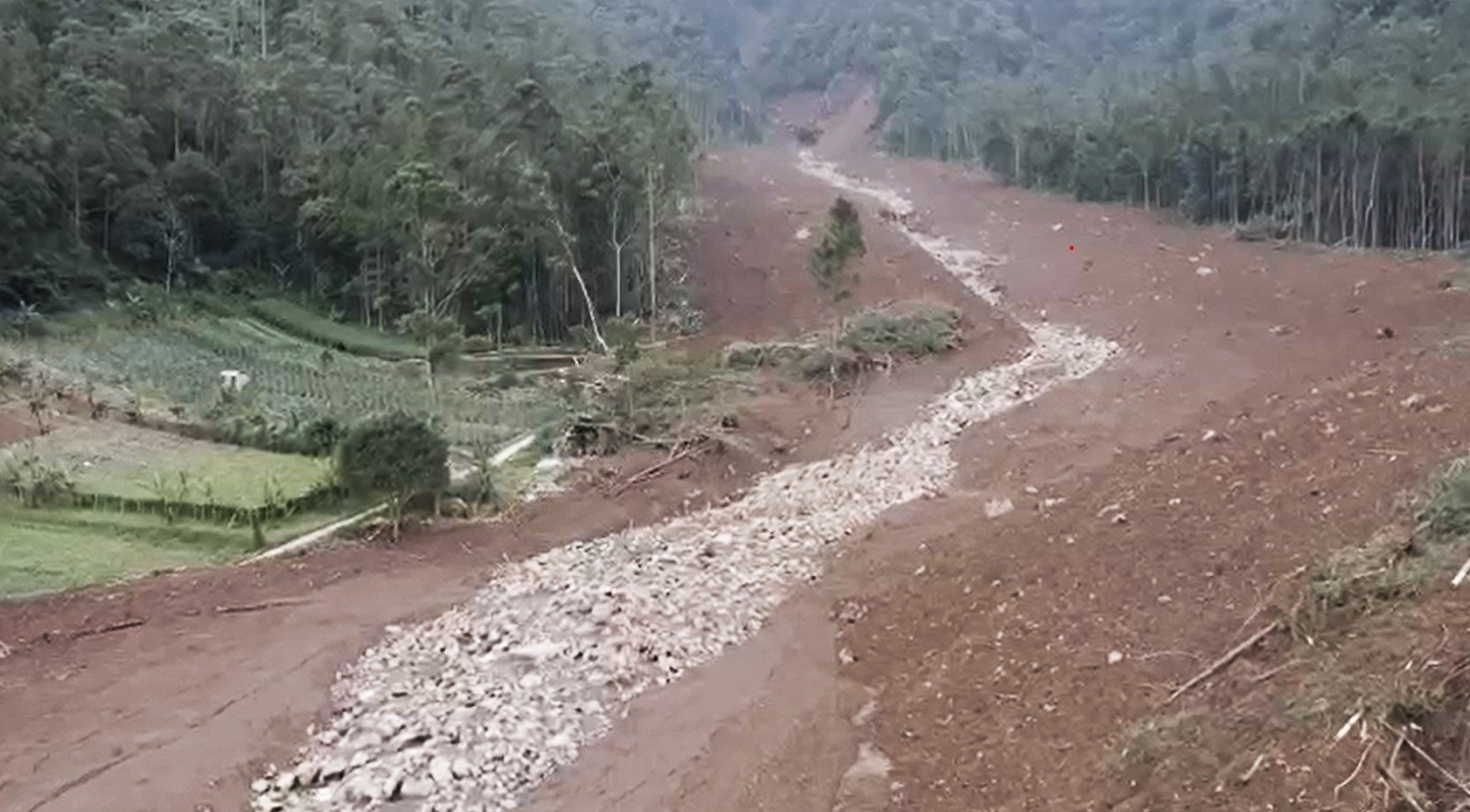
One crucial finding in this event was the indication of a landslide occurring upstream along one of the river channels on the southern slopes of Mount Burangrang. The landslide blocked the river channel, forming a natural dam, or landslide dam. As the channel was obstructed, water flow was temporarily impounded, creating a ponded area upstream along with the accumulation of sediments ranging from mud and sand to large rock fragments.
When the natural dam could no longer withstand the increasing water pressure, it collapsed, triggering a mudflow that surged downstream along the existing river channel. Dr. Imam emphasized that this flow was not merely water, but a fast-moving mixture of mud, rock boulders, and tree branches, resulting in far more destructive impacts.
“The residents’ houses did not collapse due to slope failure at their locations, but were affected by landslide material transported from upstream through the river channel,” he said.
Such flows generally possess far greater destructive power than ordinary floods due to their heavy sediment load. For this reason, the phenomenon is more accurately classified as a mudflow, or potentially a debris flow. This also explains the severe damage observed along the flow path and within riverbank areas, even though these locations were not situated directly within the landslide source zone.
Dr. Imam also warned of potential secondary hazards, as indications of additional blockages remain upstream. If heavy rainfall occurs again, water accumulation behind these blockages could once more collapse and trigger dangerous mudflows threatening downstream areas.
Living Near Riverbanks Requires High Vigilance
Although most of the affected areas fall within regions categorized as having low to moderate landslide susceptibility at the regional scale, Dr. Imam stressed that settlements located along riverbanks face a high risk of being hit by mudflows or even debris flows originating upstream.
“Hazards do not always come from the slope on which a house stands. They can come from drainage systems directly connected to steep slopes upstream,” he said.
He also highlighted the importance of vegetation in maintaining slope stability. Vegetation contributes mechanically through root systems that enhance soil cohesion and hydrologically by slowing down soil saturation during rainfall.
Science-Based Mitigation
In addressing the hazards of mudflows and debris flows, Dr. Imam outlined three main mitigation approaches. First, slope stabilization in upstream areas, particularly on slopes prone to landslides that may supply material and block river channels. Second, monitoring flow tracks using technologies such as geophones, vibration sensors, and surveillance cameras to detect material movement at an early stage. Third, protection along flow paths and downstream areas through the construction of debris flow barriers, deflection walls, debris fences, or debris flow catch basins.
“The most destructive element is not the water itself, but the sediment carried by the flow. Therefore, mitigation systems must focus on sediment control,” he explained.
Natural Warning Signs to Watch For
As part of non-structural mitigation efforts, Dr. Imam emphasized the importance of increasing public awareness of natural warning signs. One frequently overlooked indicator is the sudden reduction or disappearance of river flow while heavy rain is still ongoing, which may signal blockage or damming upstream.
“If a river that normally flows suddenly recedes during heavy rainfall, people must remain alert and immediately move away from the river channel,” he said.
Through this incident, Dr. Imam hopes that public understanding of landslide hazards will no longer be limited to the collapse of slopes alone, but will also encompass the risks posed by sediment-laden flows, including mudflows and debris flows from upstream, which can occur without clear visual warning signs in residential areas.