


EduAsiaNews, Jember – In today’s dynamic era, valuable data is data that can “speak”—presented visually and capable of accurately depicting spatial realities. This transformation from numbers into maps is being actively promoted by University of Jember (UNEJ) in collaboration with the Geospatial Information Agency (BIG) to support the implementation of the One Map Policy, as conveyed by Bayu Taruna Widjaja Putra, a precision agriculture expert at UNEJ.
In East Java, BIG has established cooperation with UNEJ in mapping and managing geospatial data, particularly in the Tapal Kuda region. This collaboration positions UNEJ as a strategic partner in supporting the structuring and harmonization of regional data as a basis for regional development policymaking.
UNEJ oversees the Tapal Kuda area, which includes Lumajang, Bondowoso, Jember, Banyuwangi, and Probolinggo. The utilization of geospatial data in this region still needs to be enhanced, providing opportunities for UNEJ to assist local governments in managing spatial data.
In practice, local governments do not always need to coordinate directly with BIG. The presence of UNEJ serves as an intermediary in addressing various spatial issues at the regional level.
“Local governments do not need to go all the way to BIG. UNEJ can assist in resolving spatial-related issues in the Tapal Kuda region,” said Prof. Bayu.
He noted that the use of geospatial data in the Tapal Kuda region remains relatively low compared to other areas such as West Java, where data management is more advanced. Additionally, there is still a tendency among local governments to rely on map ownership without ensuring data updates and accuracy.
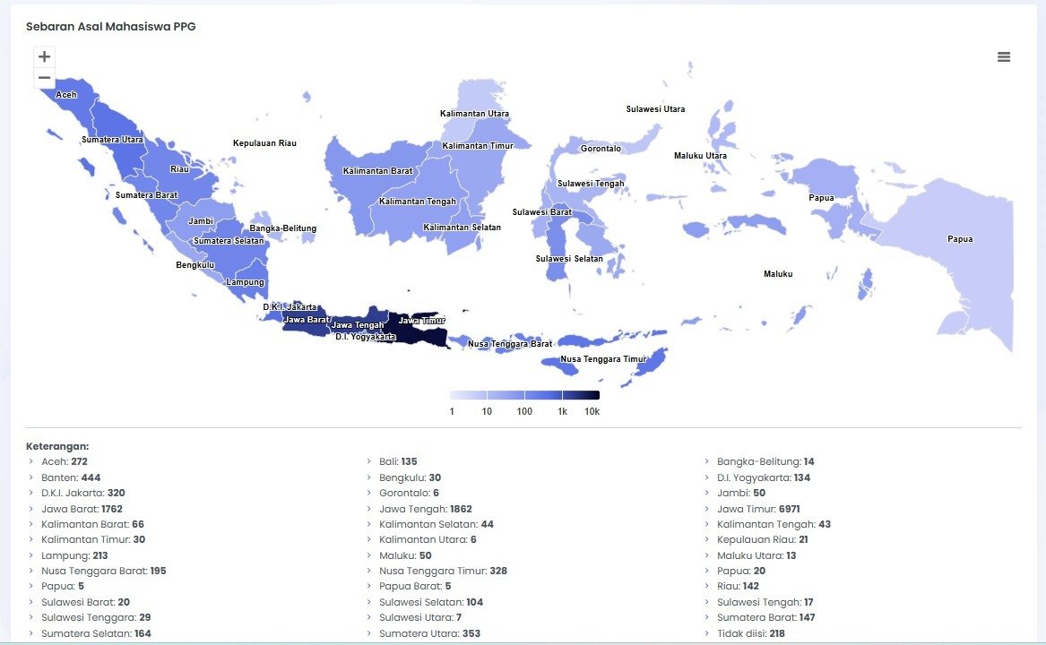
Prof. Bayu encourages a shift in data presentation paradigms—from tabular formats to spatial-based data utilization. For example, in public information services such as campus Information and Documentation Management Officers (PPID), data on students’ regional origins is no longer merely presented in rows of numbers but projected into digital maps in the form of location points or color gradients (heatmaps).
According to him, this spatial-based approach provides more informative insights. Data not only shows quantity but also location and distribution in the field. This innovation can enhance the quality of public information presentation, particularly within academic institutions.
A similar approach can be applied at the local government level. Prof. Bayu highlighted that some data is still presented in tabular form without adequate spatial information, such as the boundaries of regional assets or public facilities like cemetery areas.
“Many cemetery areas are only recorded as a certain number of square meters in tabular data, without actual polygon boundaries on maps. With accurate spatial data, local governments can predict remaining land capacity and take preventive spatial planning measures,” he explained.
This collaboration also includes mentoring and capacity-building activities, such as training for regional officials and the development of web-based systems for geospatial data management. These efforts aim to strengthen human resources and data management systems as a foundation for further technological utilization, including Artificial Intelligence (AI).
In its development, UNEJ has also utilized computational infrastructure to support data processing, including AI development. This technology assists in analyzing data, such as identifying agricultural commodities based on spatial data and field imagery.
AI has begun to be applied in geospatial mapping activities, including the mapping of cocoa commodities in Banyuwangi. This involves identifying plantation locations, cultivated areas, and environmental conditions affecting crop growth based on spatial data and field observations.
Through this approach, data not only indicates the presence of commodities but also provides detailed insights into distribution and regional potential. This mapping serves as an initial step in building a more structured agricultural database for future development.
However, the use of AI at the local government level is still in its early stages. “Local governments are currently focused on system improvements and human resource development. Once data and systems are well established, AI can then be further utilized,” Prof. Bayu added.
Within this collaboration between UNEJ and BIG, the involvement of the academic community plays a crucial role in supporting geospatial data management. The partnership focuses not only on system development but also on optimizing the roles of lecturers and students.
Lecturers contribute expertise in information technology and geospatial systems through the tridharma framework, ranging from assisting local governments to knowledge transfer. Meanwhile, students have opportunities to engage directly through internships and collaborative projects linked to partnerships between UNEJ, BIG, and local governments.
Students are encouraged to contribute not only technically but also in developing cross-disciplinary strategic approaches, reflecting the multidisciplinary nature of geospatial technology, which can be applied across sectors such as agriculture, spatial planning, forestry, and regional development.
The development of geospatial data by UNEJ in collaboration with BIG aligns with the implementation of the One Map Policy, which aims to harmonize spatial data nationally. This policy is expected to eliminate discrepancies between institutions that have often hindered development planning.
Through synergy among lecturers, students, and external partners, UNEJ serves not only as a center for knowledge development but also as a driving force in leveraging geospatial technology to support regional development and improve data-driven policymaking.